
 |
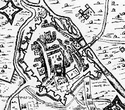
Extract from Clampe's map of the siege of Newark. |
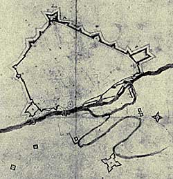 |
Extract from the map of the civil war siege works at Newark now in the possession of Newark Museum. It was probably drawn by a Royalist engineer. |
Cartographic
Printed
- An exact Platform of all the redoubts, forts and fortifications, which were about the town of Newark upon Trent… when it was unhappily besieged the 6 day of March 1644/5 by the … Scotch aramy, and the form of all the entrenchments, batteries and approaches raised and carried on by them against it, till it was surrendered on the 8th May, 1646. “Taken by their Chief Enginier during that transaction from whose drawing this is correctly copied and has been compared with the remains of the said place by Sam[uel] Buck. June 1725. R Clampe delin. 1646. S. Buck, sculp 1726. [Nottinghamshire Archives Ne 2 S]
Manuscript
- The siege of Newark by the English and Scotch armies consisting of sixteen thousand men which continued twenty and six weeks, and was surrendered the eight of May 1646, by his Maties Commander to the Committee of both Kingdomes for the Parliament. [Newark Museum (41-35)]
- A description of the seidge of Newark upon Trent with the fortifications about the Towne as also the forme of all the Entrenchments forts redouts batteries and approaches made against it under the conduct of the Earle of Leven Capt: Genll: of the Scots Army and Coll: Genll: Pointz and Coll: Rosseter commanders in Cheife of the English forces, it begun the 6th of March 1645 and ended the 8th of May 1646. Described by Richard Clampe, Ingenier. [British Library (maps) 4670 (i)]