
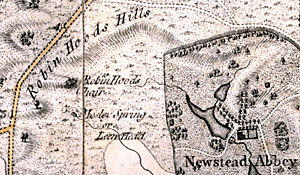
Robin Hood's Hills and Robin Hood's Chair as depicted on John Chapman's Map of Nottinghamshire (1774).
Cartographic
The nature of the Robin Hood legend means that it is hard to find maps related directly to the outlaw’s historical movements. However it is possible to look at the areas in which he was reported to have lived and so to gain an impression of the relationship he might have had with the surrounding areas. Maps can also enable us as to view the effect that the legend has had on the landscape over the years, in terms of place-names featuring the prefix ‘Robin Hood’.
These represent some of the earliest extant maps relating to Sherwood Forest and are to be found in the Manuscripts and Special Collections department of the University of Nottingham:
- Boulton, H. The Sherwood Forest Book
In the Kings Meadow Campus, East Midlands Special Collection Not1.D22 SHE - Bankes, R., Sherwood Forest in 1609: a Crown Survey
Kings Meadow Campus, East Midlands Special Collection Not/Thor Soc/40 - Moll, H., Map of Nottinghamshire, 1724
East Midlands Special Collection Not 1.B8 D24
In addition useful maps are contained within:
- A. J. Pollard, Imagining Robin Hood (2007)
- Dobson and Taylor, Rymes of Robyn Hood (1997)
The map included on this website, describing the Haunts of Robin Hood, gives an interesting perspective of the proximity of Robin Hood’s two key settings, as well as providing a key to significant place-name features:
www.highton.org/robinhoodold/haunts.htm
Robin Hood Outlaw Legend of Loxley shows an extract from the ordnance survey map, picturing the legend’s Yorkshire home:
myweb.ecomplanet.com/kirk6479/mycustompage0038.htm