
Overview
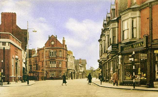
The Square, Beeston in 1958 (photograph courtesy of David Hallam).
Although situated only four miles west of the centre of the City of Nottingham, Beeston has retained a feeling of independence. From an administrative point of view it remains part of the County rather than the City and is separated from Nottingham itself by the open spaces of the University campus and Wollaton Park. That geographical barrier, coupled with its own strong commercial and industrial base which has adapted to change over the years and, by no means least, the existence of a strong Non-Conformist tradition, resulted in a palpable independence of spirit amongst its population. It remains to be seen if the development of a tramline connection with the City, currently under development, will have its effect on this autonomy.
Since Local Government reorganisation in the early 1970s, Beeston has been part of Broxtowe Borough Council. This takes in the former Beeston & Stapleford Urban District Council and parts of what was Basford Rural District Council. The name of Broxtowe is derived from the old Wapentake for the area but is confusing to many in present day use as it is the same as a well-known housing estate in Nottingham City. The former Urban District, now part of the Borough, included the former villages or communities of Chilwell, Attenborough, Toton, Bramcote and Stapleford. Today, it is often difficult for visitors to differentiate between these communities but they have developed from distinct origins with different strengths and outlook.
Beeston’s southern boundary is marked by the River Trent and it was that route which would have been taken by its earliest visitors during the Stone Age - flint axes from that era have been found - and many centuries later by those in the Bronze Age (4000 to 1000 BC). Three canoes from this era, discovered in 1938 by the river, with spearheads, traces of a structure and some skeletal remains appear to confirm that the area was definitely settled by that time. Later in this evolution, the area appears to have been on the periphery of the Roman occupation, being cushioned from the main activity which took place south of the Trent. Nevertheless, traces from this time have been found over the years.
All these settlers must have been attracted by the site - lush meadows by the river, a higher gravel-based terrace and still higher ground to the north based on bunter sandstone, with an abundant supply of good water, on which to grow seasonal crops. It was this ideal site which eventually attracted the Anglo-Saxons to settle during their attacks through Nottinghamshire and adjoining areas during the sixth century. They formed a village on the terrace and established their traditional three-field farming methods.
The name "Beeston" dates from that time; it is based on the excellent wild grass which the settlers found so useful in the riverside meadows - the Saxon words "beos" meaning bent or rough grass and "tun", a place or settlement - the place where the bent grasses grow.
Some four centuries of settlement followed, interrupted and influenced by incursions by Danish and Norman invaders. The Domesday Survey of 1086, where the modern Beeston is included only in part - approximately 360 acres out of a total area of some 1500 acres - marked the start of the Medieval period noted for the influence of the Church and the Lord of the Manor. Beeston was ecclesiastically under the control of Lenton Priory and the main overlordship was in the hands of William Peveril and was eventually granted to Hugh de Beauchamp.
Although Christianity was adopted by the Anglo-Saxons and they would have had places of worship, the first definite evidence of a church does not appear until the end of the 12th Century. Over the centuries this was to be rebuilt several times, notably in the 16th century and was eventually, in 1843, almost completely rebuilt to become the church building, dedicated to St John the Baptist, we see today. It recent years, the interior of this Victorian building has been re-ordered to be more appropriate to modern usage. Nevertheless, a few fragments from earlier structures can still be found there.
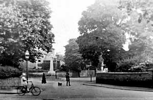
The Cross, Beeston c.1920.
For some 700 years, the village followed the pattern of change and everyday existence which was experienced by many settlements of this type in the area. The economy was almost entirely agricultural, the village core was clustered around what was Market Street and is now Middle Street, with a market cross at its junction with what is now Dovecote Lane and Church Street - the site shown in the picture on the left (in about 1920, with the War Memorial standing where the cross would have been). The church, manor house and farm and other older building in the adjacent present West End are all pointers to this scene. The traditional three fields and meadow lay to the north and south of that core. After the Dissolution of the Monasteries in 1537-9, Beeston was taken over by the Crown and eventually the Lordship of the Manor was granted to the Strey Family who occupied and developed the Manor House - tastefully restored in 1981 - until the last of the line died in 1802.
The church registers, dating from 1558, are amongst the most complete in the County although there are some defective years in the first decade, a gap caused by missing pages from 1611 to 1637 and few entries, no marriages, during the Civil War period. The years 1593 and 1594 record the devastating effect of an arrival of what is likely to have been bubonic plague. 138 deaths - perhaps 40% of the population - occurred as a result during a 10 month period, many being buried in a Plague Pit, believed to be at the east side of the churchyard.
The 17th Century saw the first stirrings of change when initiatives from individuals led to a degree of enclosure and a resulting reorganisation of the three-field layout. The act of enclosure, which transferred rights in common into individual ownership, while often having a devastating effect on the small farmer, did have the advantage of encouraging development and diversification away from a purely agricultural economy. These changes were eventually encouraged by improvements in communication and transport facilities - the Nottingham to Derby road to the north of the village was turnpiked in 1759 with a branch to Sawley Ferry passing along the line of the present High Road. At the end of the 18th century, the River Trent was improved for transport purposes by the construction of a weir at Beeston and a canal to provide access to Nottingham. General enclosure was completed by Act of Parliament passed in 1806, making the way clear for wholesale change. This gained even more impetus in 1839 when the railway was opened from Nottingham to Derby with a station at Beeston.
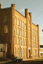
Anglo Scotian Mills (photograph courtesy of David Hallam).
By the end of the 17th century traditional rural crafts had begun to be augmented by the establishment of framework knitting of hosiery. Although this began as a cottage industry, here as elsewhere it provided a focus for change in the organisation of the working environment which progressed through the evolvement of houses with an upper room for the frames with long windows to give light, to small workshops built in backyards and, eventually, the fully developed factory concept which formed an important part of the Industrial Revolution throughout Britain. In Beeston, as in other areas, the hosiery industry fell on harder times and, as in Nottingham, there was a transition to the more fashionable lace making. After land became available following the Enclosure Act of 1806 there was a rash of small factory building for this purpose which was to grow according to demand and individual fortunes for the rest of the 19th Century. Early development of this type took place largely in the Chapel Street (now no more, being on the site of The Square shopping development in the 1960s) and Villa Street where the area at the north end became the site for a more major factory, powered by steam and housing 92 machines, which came under the ownership of William Felkin (who wrote A History of Machine Wrought Hosiery and Lace Manufacturers) and his sons. This was followed by other purpose-built enterprises in that area, John Pollard’s Swiss Mills and the large-scale operation of Frank Wilkinson’s Anglo Scotian Mills which had 1000 employees by the time of a disastrous fire in 1886. A rebuild was also destroyed by fire six years later but a further rebuild with a castellated, Victorian-Gothic facade onto Wollaton Road survives today, albeit now converted for apartment living.
Important as these industries were to Beeston, they were not the only employer of size. A silk mill, was built in 1826 which had mixed fortunes and several ownerships during its productive years which finally ended in 1902. In 1831 it was the target for Reform Bill rioters who burnt it down in protest to the opposition to the Bill by the then owner of the mill, William Lowe. By 1851 however, after a rebuild, it was employing 580 from the area - predominantly women and children - and was said to be the largest silk mill between there and Derby.
This huge increase in commercial and industrial activity attracted corresponding increases in population. In the early 18th century, this has been estimated at about 300 but this had risen comparatively rapidly to 948 in 1801. This continued dramatically during the first half of the 19th century, settled for two decades and then surged again to reach a 10 fold increase during the century as a whole - and then nearly doubled again in the next 30 years.
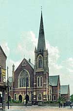
Methodist Church on Chilwell Road.
Industrialisation also had its influence on religious attitudes with many working people turning to the growing number of Non-Conformist Chapels for their salvation. In 1798 the New Connexion Methodists came to the village and had built a chapel by 1805. This was followed by the Wesleyan Methodists who first took over the New Connexion chapel and then built their own larger building. Other Methodist sects also developed and built in the developing community. The Baptists were established by 1803 and soon built premises on Nether Street, a building from which emerged the famous Dr John Clifford. His parents had moved to Beeston soon after his birth in Sawley in 1836, and from very humble beginnings and early work as a lad in a local lace factory, he went on to train at a Theological College in Leicester and then became a nationally influential figure and one of the century’s greatest champions of non-denominational state education. In 1902 the Wesleyan Methodists opened their fine Victorian Gothic church on Chilwell Road which continues to prosper and expand to this day. Otherwise, the national amalgamation of the strands of Methodism, which occurred in 1907 and 1932, brought a rationalisation of the number of buildings in use.
Education in Beeston in the early part of the 19th Century was available from 1834 at the Church of England run National School on Brown Lane (now Station Road) or the corresponding Wesleyan Methodist Day School on Chapel Street which opened in 1839. The national opposition to these denominational schools was addressed by the 1874 Education Act and by 1882 Beeston provided its first Board School on Church Street followed, in 1898, by another on Nether Street.
By the end of the 19th Century, the next phase of Beeston’s industrialisation was well underway, taking advantage of the relatively inexpensive, large tracts of land that were available in the lower-lying parts of Beeston – a location near to the railway and still close enough to the centre of Beeston to attract labour. Between 1880 and the turn of the century, Thomas Humber and his partners were making bicycles and eventually motor-cycles and cars at what became a large factory in that area, at the junction of what is now Queens Road and Humber Road. At its height it employed 2000 although this came to an abrupt end in 1907 when the company rationalised its facilities and moved all operations to Coventry.
Advert from 1932 (photograph courtesy of David Hallam).
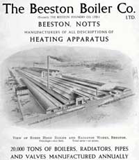
Next to take advantage of the available land beside the railway was The Beeston Foundry Ltd (later to become The Beeston Boiler Company Ltd) developed by the Pearson family in 1896, on a 28 acre site there. The firm grew strongly, soon becoming a major player in the industrial, commercial and domestic heating market, both at home and throughout the world, for almost 90 years until it closed on this site in 1985. The company had interesting origins which largely mirrored the local industrial evolution generally. By about 1841, local joiner Robert Foster had begun making horticultural buildings, soon began to find customers for his innovative designs throughout the country and opened a manufacturing unit, on Brown Lane (now Station Road) in the centre of Beeston. His progress was assisted greatly by an early collaboration with John Royston Pearson, a successful nurseryman in the adjacent village of Chilwell. By the 1880s, Pearson’s eldest son, John Henry Pearson, was actively involved with Foster in the business, eventually bought him out in 1883 and was joined by brothers Louis & Douglas Pearson. As Foster & Pearson Limited, the company continued to supply greenhouses and conservatories to many of the large estates throughout Britain and even abroad. Robert Foster had been casting fittings and greenhouse heating from the early days of the company and it was this side of the business that was developed into Beeston Foundry by the Pearson brothers.
Further major industry arrived in 1901 when the National Telephone Company moved onto a site in Beeston Rylands – another part of the low-lying area of Beeston, south of the railway, which runs down to the River - which soon become British L. M. Ericsson Telephone Company and was eventually to employ about 5000 producing telephone exchanges and equipment for the world market. Several generations of Beeston’s young people benefited greatly from its apprenticeships and training in was able to offer over the years. After being taken over by Plessey in 1961 and then, in turn, by Siemens in 1989, it was eventually closed in 2008. Happily, the site is gradually being developed as an industrial park where new technologies are already emerging.
In addition to these major employers, the town attracted a diversity of industry and enterprises during the 20th century and continues to do so. These have provided a viable alternative to those industries which developed and died during earlier centuries. Not least of these is the huge Boots pharmaceutical factory which lies partly in Beeston and partly in the City. Inevitably also, the last half of the 20th Century and continuing into the 21st, the town has seen an increasing trend towards its use as a dormitory suburb of the City and as a shopping centre for surrounding communities. Over the years Beeston has adapted to each of these changing roles and has the flexibility and spirit to respond to the changes which the future will bring.
![]()
![]()