
Cartographic
Printed
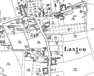
Laxton on the Ordnance Survey 25" to the mile map of 1899/1900.
George Sanderson’s Map of the country twenty miles around Mansfield, originally published in 1835, covers most of Nottinghamshire (including Laxton) at a useful scale of 2¼ inches to 1 mile (showing fields, individual buildings, roads, industrial sites, parish and township boundaries, etc). A facsimile version has been produced by Nottinghamshire and Derbyshire Library Services:
- George Sanderson, Twenty miles around Mansfield, 1835 (Reprinted by Derbyshire and Nottinghamshire County Councils, 2001)
A wide range of Ordnance Survey maps from the 1840s to the present day are available at Nottinghamshire Local Studies Libraries and Nottinghamshire Archives. The earliest large scale (25" and 6” to the mile) coverage dates from the 1880s and an online digital archive of these maps for the whole county is accessible through the Old Maps and Nottinghamshire Insight Mapping websites:
Manuscript
Bodleian Library, Oxford
The Bodleian holds Mark Pierce's impressive 1635 manuscript map, ‘A plat and description of the whole mannor & Lordship of Laxton with Laxton Moorehouse in ye county of Nottingham and also of the mannor & Lordship of Kneesall lying adiacent to ye aforesaid mannor of Laxton’. The map is fully coloured in nine pieces, each measuring approximately 76cm x 59cm, and drawn at a scale of around 1:3,950.
The Library also possesses the accompanying terrier, which describes each of the thousands of strips of land shown on the map, identifying the person farming each strip, and its acreage.
The 1635 map and terrier have been digitized and can be viewed on the Bodleian website:
- ‘A plat and description of the whole mannor & Lordship of Laxton with Laxton Moorehouse in ye county of Nottingham and also of the mannor & Lordship of Kneesall lying adiacent to ye aforesaid mannor of Laxton’
- ‘A booke of survaye of the whole mannor and lordshipp of Laxton with Laxton Moorehouse in the county of Nottingham’
Manuscripts and Special Collections, University of Nottingham
Manuscripts and Special Collections hold a number of maps of Laxton. They are listed a described on the online catalogue. The department has also produced a useful guide to archival resources relating to the history of the village that includes a section on maps: