
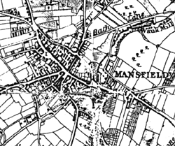
Mansfield in the 1830s (detail from 'Twenty Miles Round Mansfield' by George Sanderson, 1835.
Cartographic
Printed
The D. J. Bradbury maps, produced retrospectively, show the town centre in great detail primarily derived from the 1824 survey of the town and the Tudor era produced from court rolls. The 1835 Sanderson map revolves around Mansfield, showing substantial detail at a scale of approximately two inch to the mile, while the 1774 Chapman map of Nottinghamshire indicates the size and layout of the town. The 1914 1/2500 Ordnance Survey map has been published at 14 inch to the mile and is available from www.alangodfreymaps.co.uk/emidlands.htm. An excellent 10ft-to-one-mile O.S. map of Mansfield (1877) was produced as well as the standard Ordnance Survey productions. The latter decades of the twentieth century are also well mapped by the Goad collection, to found at the Mansfield Library. Many sale catalogues of the aforementioned yards are available at the Nottinghamshire Archives Office.
Manuscript
The town appears on several ancient maps of Sherwood Forest as well as various Manorial maps (Nottinghamshire Archive Office holds several such maps). A Victorian town centre map that accompanies the 1856 Land Valuation can be viewed either in the Nottinghamshire Archive office or Mansfield Library. Excellent Tithe & Enclosure maps are deposited in the Nottinghamshire Archive Office. On a smaller scale there is a substantial collection of Building Control plans housed in the Archive Office. Mansfield has also been the subject of the sale of complete yards, which in turn provided large-scale maps of the immediate vicinities; again these are deposited in the County Archive Office.