
Cartographic
Around 115 pre-1800 manuscript maps covering the whole of the Forest, or parts of it, survive. See the following for details:
- H. Nichols, Local maps of Nottinghamshire to 1800: an inventory, West Bridgford: Nottinghamshire County Council (1987)
A useful study of the surviving pre-19th century maps of Sherwood Forest is:
- Steph Mastoris, ‘The pleasant and glorious condition of this noble forest’ – mapping Sherwood Forest before 1800, in J V Beckett (ed.) Nottinghamshire past, Merton Priory Press (2003)
Printed maps
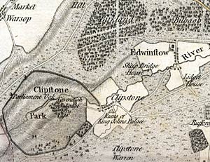
Detail of Chapman's map of Nottinghamshire showing Clipstone Park, Edwinstowe and the woodlands of Bilhaugh and Birklands.
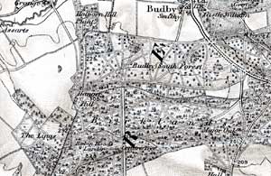
Detail of an Ordnance Survey map of c.1900 showing Budby South Forest, Birklands and Bilhaugh.
John Chapman’s map of Nottinghamshire (1774) is the earliest printed map at a sufficiently useful scale (1 statute mile to one inch) to provide basic information on town and village layout and the existence of landscape features such as roads, parkland and mills. A facsimile version was published by Nottinghamshire County Council in 2003.
George Sanderson’s map, Twenty miles around Mansfield, originally published in 1835, covers most of Nottinghamshire (including the Sherwood Forest area) at a scale of 2¼ inches to 1 mile (showing fields, individual buildings, roads, industrial sites, parish and township boundaries, etc) and a reproduction has been published by Nottinghamshire and Derbyshire Library Services (2001).
Ordnance Survey
Large scale Ordnance Survey maps from the late 19th and early 20th centuries show the landscape of Sherwood Forest in great detail:
- 1:2500 (25” to the mile) and 1:10560 (6” to the mile) published in 1884-85 (2nd edition in 1900; third edition in 1921; ‘Revision of 1938’ in c.1948-50)
These maps are available online:
Manuscript maps
National Archives
- Map of the southern part of Sherwood Forest, comprising an area between the rivers Trent, Leen and Doverbeck, and north to Bestwood Park, Arnold and Sansum Wood and showing waterways, woodlands, boundaries of lordships, fields (some with names of occupiers and acreages), towns in plan and roads. (1609) [MR 1/1142]
[The map has been re-drawn and published with the accompanying survey in Stephanos Mastoris and Sue Groves (eds.) Sherwood Forest in 1609. A Crown survey by Richard Bankes, Thoroton Society Record Series, vol. XL (1997)].
- Gleadthorpe (possibly by Richard Bankes), early 17th century [MPF 295]
- Plan of Sir Charles Cavendish's estate comprising the village of Carburton in Edwinstowe, Roome Woode, Burnt Hastings, Hurst Field and Welbeck Abbey, 1615 [MR 1/429/1]
- Plan of lands in and around Kirkby in Ashfield, showing waste land and wood, and denoting the lands of Sir Charles Cavendish, 1615 [MR 1/429/2]
- Plan of part of Sherwood Forest called Birkland, bounded by Budby, Clipston and Warston parishes. No endorsement concerning enrolment of any deed to which this plan might relate. (c.1835) [MPE 1/3/58]
- Two versions of a plan of the Hays of Birkland and Bilhagh. ( 1793) [MPE 1/339]
- 'A Plan of the Hays of Birkland and Bilhagh within the Forest of Sherwood in the County of Nottingham belonging to the Crown. Surveyed in the year 1791 by Order of the Commissioners appointed by an Act of Parliament passed in the 26th Year of King George the IIId., [?1793], [MPE 1/340]
- 'A Plan of the Hays of Birkland and Bilhagh within the Forest of Sherwood in the County of Nottingham belonging to the Crown. Surveyed in the year 1791 by Order of the Commissioners appointed by an Act of Parliament passed in the 26th Year of King George the IIId., [?1793], [MPE 1/341]
- 'A Plan of the Hays of Birkland and Bilhagh within the Forest of Sherwood in the County of Nottingham belonging to the Crown. Surveyed in the year 1791 by Order of the Commissioners appointed by an Act of Parliament passed in the 26th Year of King George the 3rd., 1793, [MPE 1/342]
- 'A Plan of the Hays of Birkland and Bilhagh within the Forest of Sherwood in the County of Nottingham belonging to the Crown. Surveyed in the year 1791 by Order of the Commissioners appointed by an Act of Parliament passed in the 26th Year of King George the III d., 1791, [MPE 1/547]
- Return relating to the cutting of trees in the forest 1663-1664, apparently not relating to the map at (2). (2) 'North-East part of Billow [Bilhaugh in Edwinstowe], the South-East part of Thorsby and the South-West part of Palethrop [both in Perlethorpe cum Budby]'., [1664]-[?1683], [MPE 1/1467]
- Two plans of areas in Sherwood Forest. (1) Plan of Nomans Wood, showing acreage and roads. Scale: 1 inch to 10 chains. Compass indicator. (2) Plan of the forest, showing names of places, named fields, parks, chases, and roads. Dimensions: (1) 37., [early 19th century], [MPE 1/1468]
Belvoir Castle Manuscripts
- Map of Sherwood Forest, c.1400 — the map is reproduced and discussed in detail in Barley, M. W. 'Sherwood Forest, Nottinghamshire', in Skelton, R. A. and Harvey, P. D. A., eds., Local Maps and Plans from Medieval England (Oxford, Clarendon Press, 1986), 131-139, ill
- Map of Sherwood Forest (late 16th/early 17th century) – the map is illustrated in D Price, Medieval land surveying and topographical maps, Geographical Journal, 121 (1955), plate 3
Nottingham City Museums
- Kighill and Ravenshead wastes by Thomas Langdon, 1613 [Fraser 262]
Nottinghamshire Archives
- Map showing the conjunction of the boundaries of the lordships of Warsop, Clipstone and Birklands wood, 1606 [WP 5 S]
- Sketch map showing brecks in Allamore Side, Blidworth, later 17th century [BD 6 S]
- Map of Lenton and Radford by Richard Smythe, 1632 [RD 3 L]
- Map of Rufford lordship by John Bunting, 1637 [RF 4 L]
British Library
- 'The fforest of Sherwoode’ (late 16th/early 17th century) [BL, Additional MSS, 74219] — the map is illustrated and discussed in detail in S Mastoris, 'A newly discovered perambulation map of Sherwood Forest in the early seventeenth century', Transactions of the Thoroton Society, 102 (1998), 79-92
Portland Estate Office, Welbeck Abbey
- The Welbeck Atlas, by William Senior, includes 19 maps of estates in Nottinghamshire, 10 of which lay within Sherwood Forest (photographic copies of the maps are held at Nottinghamshire Archives) — the atlas is illustrated and discussed in detail in Steph Mastoris (ed.), The Welbeck Atlas : William Senior's maps of the estates of William Cavendish, Earl of Newcastle 1629-1640, Thoroton Society Record Series, 47 (2017)
Chatsworth House
- William Senior’s survey of the estates of the first and second Earls of Devonshire, c.1600-28, includes a map of Sutton in Ashfield — the map is illustrated in D. V. Fowkes and G. R. Potter, William Senior's survey of the estates of the First and Second Earls of Devonshire c.1600-28, Derbyshire Record Series, Volume XIII (1988), Plate 4.