
Cartographic
Printed
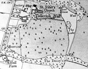
Extract from 1915 Ordnance Survey 6" to 1 mile map.
George Sanderson’s Map of the country twenty miles around Mansfield, originally published in 1835, covers most of Nottinghamshire at a useful scale of 2¼ inches to 1 mile (showing fields, individual buildings, roads, industrial sites, parish and township boundaries, etc) has been produced by Nottinghamshire and Derbyshire Library Services:
- George Sanderson, Twenty miles around Mansfield, 1835 (Reprinted by Derbyshire and Nottinghamshire County Councils, 2001)
A wide range of Ordnance Survey maps from the 1840s to the present day are available at Nottinghamshire Local Studies Libraries and Nottinghamshire Archives. The earliest large scale (25" and 6” to the mile) coverage dates from the 1880s and an online digital archive of these maps for the whole county is accessible through the Old Maps website:
Manuscript
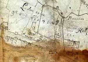 Tollerton village in 1683.
Nottinghamshire Archives
- Plan of Tollerton Hall [TO/1L]
- Map of demenese and tennants lands in the Parish of Tollerton late of the estate of Philipp Pendocke Esq., 1683 [TO/2L]
Nottingham University Manuscripts and special Collections
- Plan of Tollerton Estate
Private collection
- Map of Tollerton showing possible roadways (date unknown)
Nottingham Central Library, Local Studies Library
- 19th century map of Tollerton