
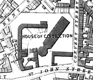
The House of Correction in Nottingham as shown on Salmon's map of 1861.
Cartographic
Printed
Ordnance Survey
Large scale Ordnance Survey maps from the late 19th and early 20th centuries show the county in great detail and show the locations of police buildings, court houses and prisons:
- 1:2500 (25” to the mile) and 1:10560 (6” to the mile) published in 1884 (1st revision in 1898; 2nd revision in 1915)
- 1:500 (10 feet to the mile) published 1884 in 10 sheets
These maps (and other large scale maps such as Salmon's map of Nottingham from 1861) can be consulted at Nottinghamshire Archives or the local studies sections at Nottingham Central Library or local public libraries.
Manuscript
Nottinghamshire Archives
- Plans of the Southwell House of Correction (1807) [X BP 6/15 and X BP 6/25]
- Southwell Tithe Award Map showing the House of Correction (1841) [AT 123/1c]