
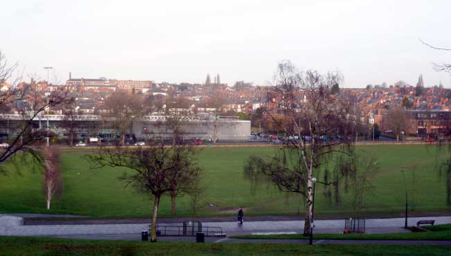
Forest Fields from the Forest Recreation Ground.
The area known as Forest Fields lies to the north of the Forest Recreation Ground, Nottingham. It inclines northwards from Gregory Boulevard, uphill, towards New Basford, and borders, on its west side, with Hyson Green. On the east side it merges with Sherwood Rise. The history of the area is rooted in the influence of the Gregory family and the development of the lace industry, especially lace manufacturer Thomas Isaac Birkin. It is also closely associated with Nottingham’s dramatic urban expansion in the late 19th century and early 1900s.
The land that became Forest Fields was allotted to the Gregory family under the Lenton and Radford Inclosure Award of 1799. Gregory estates, that included Lenton Manor, descended in 1815 to John Sherwin Gregory by the will of George de Ligne Gregory. When John died, on the 7th June 1869, his estates passed to his widow Catherine. By this period of time Nottingham borough was looking to expand its constricting mediaeval boundaries. It needed more land for houses and to extend transport connections with its growing suburbs. An 1845 Enclosure Act allowed Nottingham to inclose its former common fields, though it took twenty years to fully resolve the detailed terms of the inclosure. The formal resolution of Nottingham’s enclosure came with the 1865 Enclosure Award. Another key development in Nottingham’s inner urban expansion was the 1877 Extension Act. This piece of legislation took a number of parishes into Nottingham’s boundary including Basford, Bulwell, Sneinton, Radford and Lenton. The land to the north side of the Forest was becoming more and more desirable for builders and developers – but there was a problem. This piece of land would have been difficult to develop for housing as there was no connecting road along the southern perimeter with the Forest. To overcome this problem an agreement was reached between the Gregory trustees and Nottingham Corporation during negotiations over the Extension Bill to undertake the construction of a new road between the Mansfield Turnpike (Mansfield Road) and the Newhaven Turnpike (Alfreton Road). Perhaps not surprisingly this new road was called Gregory Boulevard! The road was to be 60 feet wide and was built under the joint supervision of the Corporation engineer and the surveyor of the Gregory Estates.
The next development in the creation of Forest Fields was the sale, in 1883, of 65 acres of land on the north side of the Forest, to Thomas Isaac Birkin for £83,499 11s 8d.. In the same year Birkin applied to the General Works & Highways Committee, through Robert Booker, to develop a grid-iron pattern of streets, on the newly-purchased land, with the overall title of ‘Forest Ville’. Thomas Birkin was the son of Richard Birkin who established a major lace business in Nottingham in the early 19th century. In1855-56, Richard, in association with his son Thomas, engaged local architect Thomas Chambers Hine to build prestigious offices and warehousing on Broadway in the Lace Market and extensive works were established in New Basford.
Lace was big business in Nottingham and its rapid growth became a major influence on the city’s landscape, as the development of Forest Fields illustrates. However, Thomas Birkin was not to have a totally free hand in the area’s development, far from it. In fact the Gregory family, through their trustees, imposed considerable restrictions on the type and appearance of buildings within 500 feet of the north side of Gregory Boulevard. This was undertaken by a covenant written into the 1883 sale conveyance. The covenant required that within 120 feet of the Boulevard only private, detached or semi-detached houses were permitted and each house had to cost at least £1000. No pair of houses was to be built within 20 feet of another. In addition the boundary walls along the Boulevard were to be built only of dressed Bulwell stone of not more than two foot high and with ‘a neat iron palisade’ running along the top of the wall of not more than 3 feet in height. The rails were probably removed during the war but the stubs are still visible. These measures ensured that the views along the Boulevard and towards Forest Ville would always reflect well on the Gregory family name.
Also there were two more ‘restrictive zones’. Within a distance of the next 180 feet only detached houses, semi-detached houses or houses in blocks of four were permitted, all with set minimum prices. No house or block of houses was to be within a distance of 10 feet of another. The prices were all lower than in the first band. In a final band of housing, for the next 200 feet, the houses were limited to detached, semi-detached or blocks of four though again with lower values than the other two bands. Within this final band houses or blocks of houses had to be at least 6 feet from each other. The total distance of the ‘restricted zone’ was 500 feet.
And there was more! On no part of the land in the ‘restricted zone’ was Birkin, or ‘his heirs or assigns’ to ‘permit or suffer the trade of a tripe boiler, fell monger, soap boiler, starch manufacturer, bone grinder, slaughterer of cattle or any noisome, noxious or offensive trade, business or occupation or calling whatever….’. In fact much of the land immediately to the north of Gregory Boulevard remained vacant though a large part of it was finally occupied in 1931 after Nottingham Corporation built the Manning Grammar School for Girls (now demolished). Even then much of the school site was grounds, gardens and playing fields.
In setting out Forest Ville, Birkin had the area divided into 209 separate lots. These were then sold off to private buyers and developers. The naming of some of the streets showed clearly the influence of Thomas Isaac Birkin. His sons were Thomas Stanley (Stanley Road), Alexander Russell (Russell Road) and Richard Leslie (Leslie Road). A Wilfred Road, named after another son, Charles Wilfred, was intended but not built. Gladstone Street and Ewart Road may also have a Birkin connection as he was President of the Nottinghamshire Liberal Association and one of its principal subscribers. The first residents of the area were professional people and employers with a good number of lace occupations represented, including lace designers, salesmen and agents.
After the development of the area’s peripheral streets in the 1880s and early 1890s the rate of development slowed down until a later phase of building between 1905 and 1914. This period of development filled the central area of Forest Ville, though this time building was on a larger scale and resulted in long ‘runs’ of red brick terraced houses built to uniform designs. The terraces stood directly onto the pavement and were generally made-up of ‘two-up, two down’ houses with privies and small backyards. Despite the overall uniformity of style there can be much diversity in details like window design, lintels, sills and doors. Occupants of these streets reflected Nottingham’s commercial and industrial diversity. There were shopkeepers, clerks, tradesmen and numerous hosiery and lace operatives such as lace winders, finishers and bobbin hands. In addition to houses there was a growing need in the area for schools. In 1888 the Nottingham School Board commissioned T.C. Hine (architect of Birkin’s Broadway buildings) to build an Infants School on Stanley Road and in 1895 High Pavement School was built by distinguished architect Albert Nelson Bromley on land between Stanley Road and Sturton Street.
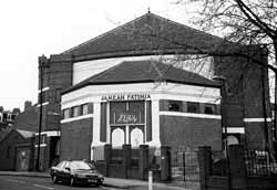
The former Apollo cinema has been converted into a mosque.
For Anglican churchgoers Forest Fields came under the parish of St Paul, Hyson Green, that had been consecrated in 1844 and in 1912 the church opened a mission hall on Russell Road. Nonconformist chapels existed in Hyson Green and New Basford and there was a Congregational was built on Gregory Boulevard in 1899 to replace an earlier iron church. Because of the ‘restricted zone’ shops were established mainly along Berridge Road and in 1911 a Co-operative store was opened on the corner of Leslie Road and Berridge Road Central. Other facilities included all kinds of sporting activities and community events on the Forest and anyone wanting to experience the dreams of the film world could go along to the Berridge Road Cinema (later the Apollo). The Apollo closed down in 1960 but the building has found has found new life as a mosque.
The study of Forest Fields can reveal rich insights into the development of an inner-city area and its streets will reward any local walk with historical clues to their history. Also, its cultural landscape has evolved rapidly in recent years. Its contemporary shops and facilities exhibit the diversity of a rich community that has found new expression in the streets, buildings and surroundings of the area.
![]()
![]()