
Cartographic
Printed
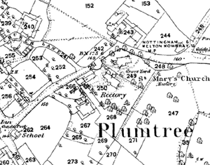
Plumtree on the Ordnance Survey 25" to the mile map of 1884.
George Sanderson’s Map of the country twenty miles around Mansfield, originally published in 1835, covers most of Nottinghamshire (including Plumtree) at a useful scale of 2¼ inches to 1 mile (showing fields, individual buildings, roads, industrial sites, parish and township boundaries, etc). A facsimile version has been produced by Nottinghamshire and Derbyshire Library Services:
- George Sanderson, Twenty miles around Mansfield, 1835 (Reprinted by Derbyshire and Nottinghamshire County Councils, 2001)
A wide range of Ordnance Survey maps from the 1840s to the present day are available at Nottinghamshire Local Studies Libraries and Nottinghamshire Archives. The earliest large scale (25" and 6” to the mile) coverage dates from the 1880s and an online digital archive of these maps for the whole county is accessible through the Old Maps and Nottinghamshire Insight Mapping websites:
Manuscript
Nottinghamshire Archives
Printed copy of manuscript enclosure map (c.1950) [DD2030/1/11].