
Cartographic
Printed
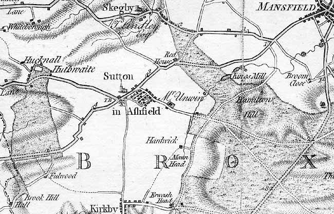 Detail of Chapman's map of Nottinghamshire (1774) showing the area around Sutton-in-Ashfield.
John Chapman’s map of Nottinghamshire (1774) is the earliest printed map at a sufficiently useful scale (1 statute mile to one inch) to provide basic information on town and village layout and the existence of landscape features such as roads, parkland and mills. A facsimile version was published by Nottinghamshire County Council in 2003.
George Sanderson’s map of the county twenty miles around Mansfield, originally published in 1835, covers most of Nottinghamshire at a useful scale of 2¼ inches to 1 mile (showing fields, individual buildings, roads, industrial sites, parish and township boundaries, etc) has been produced by Nottinghamshire and Derbyshire Library Services:
- George Sanderson, Twenty miles around Mansfield, 1835 (Reprinted by Derbyshire and Nottinghamshire County Councils, 2001)
Ordnance Survey
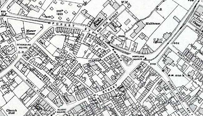 25" to the mile Ordnance Survey map of the centre of Sutton-in-Ashfield (1913-14).
Large scale Ordnance Survey maps from the late 19th and early 20th centuries show the town and its features in great detail:
- 1:2500 (25” to the mile) and 1:10560 (6” to the mile) published in 1879 (2nd edition in 1899; third edition in 1917; ‘Revision of 1938’ in 1947)
- 1:500 (10 feet to the mile) published in 1884 in 17 sheets
These maps are available online:
Manuscript
Chatsworth Archives
Although a 1609 survey of Sutton has survived and is published in Mastoris and Groves (1997) the associated plan has been lost. However, William Senior mapped the parish in 1610 and the map (in two parts) is held in the Chatsworth Archives (ref: CH34, William Senior’s surveys of the estates of the Earls of Devonshire):
- ‘The platt of ye mannor of Sutton in Ashfeeld, belonginge to the right honnorable William Lord Cavendish. Taken by William Senior (1620) – photographic copies are available at Nottinghamshire Archives (SA5 S and SA 6 S)
The associated survey has been published in Fowkes, D. V. and Potter, G. R. (eds), William Senior’s survey of the estates of the First and Second Earls of Devonshire c.1600-28, Derbyshire Record Series Volume XIII (1988), pp39-43.
Welbeck Estate
The Welbeck Estate also holds several maps of Sutton:
- Fulwood[d] fields belonging to the right honourable William Earle of Newcastle. Surveied by William Senior (1637)
- Plan of the parish of Sutton in Ashfield [on two sheets] (after 1794)
- Sutton in Ashfield and Huthwaite (1795)
- Sutton in Ashfield [plan of village centre] (c1790s)
- River Maun and roads east of Sutton town (c1790s)
- Sutton in Ashfield and Hucknall under Huthwaite enclosure (c1800s)
- Plan of the parish of Sutton in Ashfield (19th century)
Nottinghamshire Archives
- Sutton in Ashfield Parliamentary Enclosure Map (1795) [EA 90]