
 |
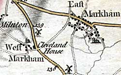
Extract from John Chapman's map of Nottinghamshire (1774). |
Cartographic
For a comprehensive and generously illustrated introduction to using maps as a historical source see:
- Paul Hindle, Maps for local historians, Chichester: Phillimore, 1998
A fascinating discussion of the ways in which maps have interacted with society over the centuries:
- Catherine Delano-Smith and Roger J. P. Kain, English maps: a history, London: British Library, 1999
Printed
John Chapman’s map of Nottinghamshire (1774) is the earliest printed map at a sufficiently useful scale (1 statute mile to one inch) to provide basic information on village layout and the existence of landscape features such as roads, parkland and mills. A facsimile version was published by Nottinghamshire County Council in 2003.
George Sanderson’s Map of the country twenty miles around Mansfield, originally published in 1835, covers most of Nottinghamshire at a useful scale of 2¼ inches to 1 mile (showing fields, individual buildings, roads, industrial sites, parish and township boundaries, etc) has been produced by Nottinghamshire and Derbyshire Library Services:
- George Sanderson, Twenty miles around Mansfield, 1835 (Reprinted by Derbyshire and Nottinghamshire County Councils, 2001)
A wide range of Ordnance Survey maps from the 1840s to the present day are available at Nottinghamshire Local Studies Libraries and Nottinghamshire Archives. The earliest large scale (25" and 6” to the mile) coverage dates from the 1880s and an online digital archive of these maps for the whole county is accessible through the Old Maps website:
Manuscript
The essential reference book for pre-19th century maps is:
- H. Nichols, Local maps of Nottinghamshire to 1800: an inventory, West Bridgford: Nottinghamshire County Council, 1987
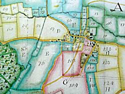 |
Extract from Isaac Messeder's 's map of Winkburn (1766). |
One of the most valuable primary sources is the estate map. There are a few examples from the 17th century, most notably William Senior’s atlas of maps produced for the Cavendish family c.1610-25, which covers a number of Nottinghamshire villages in the west of the county, (photographic copies of the maps can be seen at Nottinghamshire Archives) and Richard Bankes’ Survey of Sherwood Forest. A full transcript of the accompanying survey and a set of re-drawn maps of Carburton, Clumber, Gleadthorpe, Wilford, Lenton, Radford, Sneinton, Colwick, Stoke Bardolph, Carlton, Gedling, Burton Joyce, Bulcote, Shelford, Gunthorpe, Caythorpe, Lowdham, Lambley, Arnold, Basford, Bulwell, Bestwood Park, Woodborough, Calverton and Kirkby in Ashfield) has been published:
- S. Mastoris and S. Groves, Sherwood Forest in 1609: a Crown survey by Richard Bankes. Thorton Society Record Series, 40, 1997.
Mark Pierce’s map of Laxton village and its famous open fields (1635) is a very impressive example of its kind. A facsimile of the map is published in
- C S Orwin and C S Orwin, The open fields, 3rd Edition. Oxford, Clarendon Press, 1967.
Two estate maps of East Bridgford, dating from 1612-14, are illustrated and discussed in:
- Henstock, Adrian, ‘A Nottinghamshire village in the Jacobean period: the East Bridgford estate maps of 1612-14’, Transactions of the Thoroton Society, 100, 77-93
Tithe maps from the 1840s cover about 40% of Nottinghamshire parishes and are at a large scale. For a helpful discussion of the tithe commutation process in Nottinghamshire see:
- Beckett, J. V., Tithe commutation in Nottinghamshire in the 1830s and 1840s, Transactions of the Thoroton Society, 96, 1992, 146-165
For general background on tithe commutation:
- Roger J P Cain and Hugh Prince, Tithe surveys for historians, Phillimore, 2000
- Eric J Evans, Maps, Apportionments and the 1836 Act: a guide for local historians, British Association for Local History/Phillimore, 1997
Enclosure maps from the 18th and 19th centuries are another important source. For the definitive list of Nottinghamshire enclosure maps see:
- Tate, W.E., Parliamentary land enclosures in the county of Nottingham during the 18th and 19th centuries (1743-1868), Thoroton Society Record Series, 5, 1935
A well illustrated introduction to enclosure maps as a historical source:
- Steven Hollowell, Enclosure records for historian, Phillimore, 2000