
Cartographic
Printed
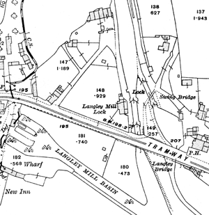
Langley Mill basin depicted on the 25" to the mile Ordnance Survey map published in 1916.
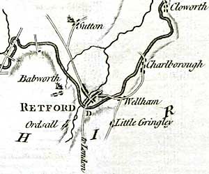
Detail from the'Plan of the intended canal from Chesterfield to the River Trent near Stockwith, surveyed in 1769'.
George Sanderson’s map, Twenty miles around Mansfield, originally published in 1835, covers most of Nottinghamshire at a useful scale of 2¼ inches to 1 mile and depicts the canals and navigable waterways mentioned in this entry. A reproduction of the map was published by Nottinghamshire and Derbyshire Library Services in 2001.
Large scale Ordnance Survey maps from the late 19th and early 20th centuries show the canals and associated structures in great detail:
- 1:2500 (25” to the mile) and 1:10560 (6” to the mile) covering the whole county published from the 1880s
- 1:500 (10 feet to the mile) of urban areas from the 1880s
See the Old Maps website for examples.
These maps can be consulted at Nottinghamshire Archives or the local studies sections of Nottingham Central Library and the larger town libraries in the county.
The Canal and River Trust Archive
A wide range of maps relating to Nottinghamshire canals is held by The Canal and River Trust Archive.
See the online catalogue for further details.
Nottinghamshire Archives
There are a number of deposited plans in the Quarter Sessions records, e.g.
- Nottingham Canal (1791) [C/QDU/DP/W/XC 2-3S 1791]
- Trent Navigation (1793) [C/QDU/DP/W/5]
- Grantham Canal (1793) [C/QDU/DP/W/XC 4S]
- Chesterfield Canal (1769) [C/QDU/DP/W/XC 6 S]
Other plans:
- Plan of the intended canal from Chesterfield to the River Trent near Stockwith, surveyed in 1769 [DD/2050/2/2]
See the online catalogue for further details:
Manuscripts and Special Collections, University of Nottingham
- Proposed canal, River Trent-Langley Bridge, 1777 [Ma 2 P/364/1]
- Plan of Nottingham-Grantham canal, 1791 [Ma 2 P/364/2]
- Plan of Nottingham-Grantham canal as it crosses Holme Pierrepont estate, 1791 [Ma 2 P/364/3]
- Plan of Nottingham-Grantham canal, 1792 [Ma 2 P/365]
- 'A Plan of the Intended Canal from Cromford to Langley-Bridge in the counties of Derby and Nottingham, with collateral Branches to the parishes of Pinkston and Selston. By E.G. Fletcher. 1789.' [Pl E12/11/16/1]
See the online catalogue for further details: mssweb.nottingham.ac.uk/catalogue/