
Structual
Standing buildings
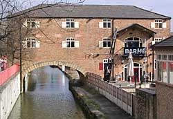
'Pickford's Depository' over the Chesterfield Canal in Worksop.
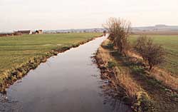
The Chesterfield Canal at Clayworth.
The Chesterfield Canal
The Chesterfield Canal originally ran 46 miles (74 km) from the River Trent at West Stockwith, Nottinghamshire to Chesterfield, Derbyshire. Currently 31.6 miles (50.9 km) of the canal is navigable: the 26 mile(41.8 km) stretch of canal between West Stockwith and the closed Norwood Tunnel and a recently opened length of canal between Chesterfield and Staveley. An ambitious plan has been developed to connect the two sections.
Other related structures and buildings include:
- The early 19th century ‘Pickford’s Depository’ warehouse over the canal and cottages at Canal Wharf, Bridge Place, Worksop (at OS grid reference SK 586792)
- Aqueduct over the River Idle in Retford (at OS grid reference SK 703808)
- 19th century warehouse and lock at Corporation Wharf, Wharf Road, Retford (at OS grid reference SK 705808)
- Drakeholes tunnel, Wiseton (at OS grid reference SK 706904)
- Probable toll house and warehouses at West Stockwith basin (at OS grid reference SK 785946)
For further information see:
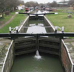
Lock originally built for the Cromford Canal at Langley Mill Basin.
The Cromford Canal
The canal was originally 14½ miles (23.3 km) in length and ran from Cromford in Derbyshire to Langley Mill. Very little of the route in Nottinghamshire (between Jacksdale and Langley Mill canal basin) survives, the result of destructive open cast coal-mining in the 1960s and 1970s. However, an 800 yard (732 meters) section of the canal at Langley Mill has been restored in recent years and Langley Bridge Lock 14 (located at the southern entrance to Langley Mill basin) is in use.
For further information see:
- Friends of the Cromford Canal website
- Michael Harrison and Valerie Roberts, A Walker's Guide to the Cromford Canal: From Langley Mill to Cromford Wharf, including the Branches to Pinxton and Leawood (revised full colour edition), Friends of the Cromford Canal, 2003
The Grantham Canal
The canal runs for 33 miles (53 km) from Grantham, falling through 18 locks to West Bridgford where it joins the River Trent. Most of the canal is still in water and work is ongoing to restore it to full navigation.
One of the few buildings that can definitely be associated with the canal is a brick and pantile-roofed warehouse at Hickling basin (at OS grid reference SK 691294).
For further information see:
The Erewash Canal
The full length of the 12-mile (19.3 km) canal is still operational, from Langley Mill basin to Trent Lock. Surviving structures in Nottinghamshire:
- Eastwood Lock (at OS grid reference SK 461459)
- Aqueduct over the River Erewash (at OS grid reference SK 462455)
For further information see:
- Arthur King and Hazel King, The Erewash Canal. A guide and History, Erewash Canal Preservation and Development Association (2006)
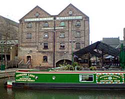
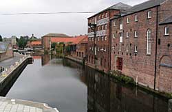
Former Fellows, Morton & Clayton warehouse, small loading cranes and basin on Canal Street, Nottingham.
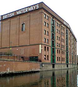
Former British Waterways warehouse dating from 1919.
Newark Town Lock and late 19th century riverside warehouses, Millgate, Newark-on-Trent.
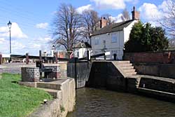
Lock and cottages at Beeston Lock.
The Nottingham Canal
The only operational section runs through the south of Nottingham city centre from the River Trent at Meadow Lane Lock and connects again with the River Trent at Beeston Lock by means of the ‘Beeston Cut/Beeston Canal.’ It has been part of the Trent Navigation since 1937.
Stretches of the canal remain in water between Awsworth and Trowell and there is a short section still visible near Eastwood but much of it has been destroyed by open-cast coal mining or by surburban development in west Nottingham.
There are several surviving buildings and structures in Nottingham:
- Former Fellows, Morton & Clayton warehouse, small loading cranes and basin on Canal Street (1895) (at OS grid reference SK 573393)
- Former British Waterways warehouse on Canal Street (1919) (at OS grid reference SK 572393)
- Meadow Lane Lock (restored in 2009) (at OS grid reference SK 582385)
- Castle Lock (at OS grid reference SK 571393)
- Remains of oval-shaped, stone-built pound that were located between Locks 15 and 16 alongside Lambourne Drive, Nottingham (at OS grid reference SK 528405)
For further information see:
- Bernard Chell, The Nottingham Canal. A history and guide, Tempus (2006)
- Steve Zaleski, The Nottingham Canal, Past and Present, The Local History Press (2001)
Trent Navigation and Beeston Canal
Still in operation.
- Cromwell Lock (at OS grid reference SK 808611)
- Holme Pierrepont Lock (at OS grid reference SK 615393)
- Lock and cottages at Beeston Lock (at OS grid reference SK 536353)
- Newark Town Lock and late 19th century riverside warehouses, Millgate, Newark-on-Trent (at OS grid reference SK 795539)
- Former 18th-century warehouses at Town Wharf, Bar Gate, Newark-on-Trent (at OS grid reference SK 797541)
Langley Mill Basin
The Cromford Canal, the Erewash Canal and the Nottingham Canal all met at Langley Mill (now in Derbyshire but before 1974 this part of the village was in Nottinghamshire). The basin was constructed by William Jessop in 1796 and restored by the Erewash Canal Preservation & Development Association in the early 1970s. A brick toll house and a swing-bridge relating to the Nottingham Canal, and the Victorian pump house are the only buildings to have survived.
The first length of the Cromford Canal here (above the junction with the Nottingham Canal) is occupied by a dry-dock, workshop and moorings belonging to Langley Mill Boatyard.