
Cartographic
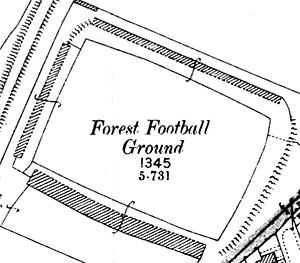
The City Ground shown on the Ordnance Survey 25" to the mile map of 1899.
Ordnance Survey
Large scale Ordnance Survey maps from the late 19th century to the present day show sporting grounds and facilities in great detail:
- 1:2500 (25” to the mile) and 1:10560 (6” to the mile) published in 1884 (1st revision in 1898; 2nd revision in 1916)
- 1:500 (10 feet to the mile) published 1884
Two online sources of historical Ordnance Survey maps of Nottinghamshire are: