
Cartographic
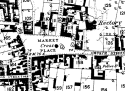 |
Extract from the Ordnance Survey 1 to 25" map of Bingham published in 1883. |
Printed
The printed maps are available at the Nottinghamshire Archives Office, the Local Studies and the Bingham libraries. They comprise:-
- 1835 George Sanderson's Map of the Country 20 Miles Round Mansfield
- Ordnance Survey first edition to 1" to 1 mile 1891 Ordnance Survey sheet 43 N.E. 62 to 1 mile
- 1900 Ordnance Survey sheets 43.3,43.4,43.7,43.8 25" to 1 mile
- 1915 Ordnance Survey sheet 43 N.E. 6" to 1 mile
- 1950 Ordnance Survey sheet 43 N.E. 6" to 1 mile
- 1967 Ordnance Survey sheets SK6839, 6939,6940, 7039, 7040, 7139, 7140. at 1:2500
Manuscript
Those listed below are in the Nottinghamshire Archives Office:-
- 1400 Glebe terrier, translated in 1622 (PR 10,282)
- 1586 Survey of Bingham (in Latin) (DDTS 14/23)
- 1687 and 1770 glebe terriers (DD T 124/16 & 17)
- 1776 Chesterfield estates survey (M 1874)
- 1792 Plan of the intended branch of the Grantham Canal (XC 4S)
- 1842 Bingham Tithe map (AT 15/1 b & 1 c)