
Structural
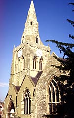 |
St. Mary and All Saints' church. |
Standing Buildings
The area around the Market Place which is a medieval planned feature, is a designated conservation area, the Buttercross of 1861 standing at its centre.
The oldest building is the church of St. Mary and All Saints parts of which can be stylistically dated to the 13th century. It is first mentioned as having a rector in 1226 and it has always been considered a wealthy benefice. Godfrey's Notes on the Churches of Nottinghamshire: Hundred of Bingham published by Phillimore 1907, Nikolaus Pevsner's Buildings of England: Nottinghamshire (2nd edition 1979 revised by Elizabeth Williamson), Adrian Henstock's History and Guide to Bingham Parish Church published by the Friends of Bingham Church 1994, and Tony Player's unpublished assignment for his M.A. in Historic Buildings Conservation for the University of Nottingham (December 1991) are useful sources.
The rest of the buildings differ from the church, being of local red brick rather than stone. Most of them date from the 18th and 19th centuries. These were originally roofed with thatch but this was replaced by slate and pantiles with the coming of the railways. Three buildings which were erected as non-conformist chapels still survive: the Wesleyan Methodist of 1818 still serves as such but plans to replace it with a new church are well advanced; the Primitive Methodist also of 1818 is now a public house and the Independent Wesleyan Methodist of 1877 is a private house.
Victorian church and chapel schools survive - the former on East Street (1845) as a church centre and the latter on Kirk Hill (1850) as a private house.
The severely truncated railway station buildings of the 1850s by T.C.Hine are a shadow of their former selves but the courthouse and police cells of a similar date serve as the town council offices on Church Street
Ruins, earthworks and archaeological remains
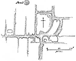 |
A plan of the earthworks in Crow Close by Hadrian Allcroft. |
Traces of a henge monument were found to the north of the town centre and covered with a metre of clay in 1972 for protection. It had been deliberately vandalised in the early part of the 20th century on the instructions of the rector.
A major Roman road - the Fosse Way - forms the western boundary of the parish, meeting the settlement or fort of Margidunum at the N.W. apex of the parish. The site of the wapentake meeting place is evident to the west side of the Fosse Way on the Toot Hill ridge.
One of the earliest so-called "deserted medieval villages" was identified at Crow Close a quarter of a mile to the east of the historic core of the town. It is a scheduled ancient monument and until it is excavated the reason for its abandonment will not be certain.
Remains of Roman habitation have been found adjacent to the site.
Landscape
The soil is Grade 1 agricultural land and for the most part heavy clay. It was cleared early for crop production, having hardly any woodland remaining today. For large building undertakings in medieval times the townspeople were awarded an allotment in Sherwood Forest at Blidworth. There are no major watercourses in the parish but before extensive drainage was carried out in the medieval period the area of Parson's Hill was an island in a swamp or lake, the Saxon settlement being sandwiched between the hill and Toot Hill which forms a ridge to the south. The A52 and the railway from Nottingham to Grantham run from west to east bisecting the parish and housing forms a linear pattern within both these constrictions.