
Cartographic
Printed
John Chapman’s map of Nottinghamshire (1774) is the earliest printed map at a sufficiently useful scale (1 statute mile to one inch) to provide basic information on town and village layout and the existence of landscape features such as roads, parkland and mills. A facsimile version was published by Nottinghamshire County Council in 2003.
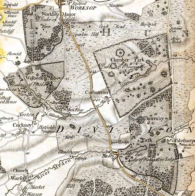 The Dukeries section of John Chapman's map of Nottinghamshire (1774).
George Sanderson’s map of the county twenty miles around Mansfield, originally published in 1835, covers most of Nottinghamshire at a scale of 2¼ inches to 1 mile (showing fields, woods, individual buildings, roads, industrial sites, parish and township boundaries, etc) has been produced by Nottinghamshire and Derbyshire Library Services:
- George Sanderson, Twenty miles around Mansfield, 1835 (Reprinted by Derbyshire and Nottinghamshire County Councils, 2001)
Ordnance Survey
 Ordnance Survey 25" to the mile map of 1914 showing Clumber House.
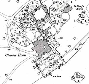
Large scale Ordnance Survey maps from the late 19th and early 20th centuries show The Dukeries area in great detail:
- 1:2500 (25” to the mile) and 1:10560 (6” to the mile) published in 1884-85 (2nd edition in 1900; third edition in 1921; ‘Revision of 1938’ in c.1948-50)
These maps are available online:
Maps and plans of houses and estates
The Royal Institute of British Architects (RIBA) hold several printed maps and plans of Thoresby Hall and park from Vitruvius Brittanicus by Colen Campbell:
- RIBA35050: Design for Thoresby House, Nottinghamshire: plan of park, gardens and plantation by Colen Campbell (1720)
- RIBA32849: Thoresby House, near Ollerton, Nottinghamshire, seat of the Marquis of Dorchester: elevation of the entrance façade by William Talman (1715)
- RIBA32848: Thoresby House, near Ollerton, Nottinghamshire, seat of the Marquis of Dorchester: plan of the first floor by William Talman (1715)
RIBA also hold a series of designs from 1857 for the proposed rebuilding of Clumber House by Sir Charles Barry which were never realised.
Manuscript maps and plans
Clumber
- Sketch map of the intended new park at Clumber entitled ‘A map of Her Majesties park at Clumber’, c.1706-9 [Portland Collection]
- ‘This park to be taken in of his Grace the Duk[ … ] Hardwick and Clumber etc within the Forest of Sherwood’, c.1710 [Portland Collection]
(Both maps are illustrated in: Morrison, S., 'The creation of Clumber Park, 1709-1714: the last royal park of Sherwood Forest', Transactions of the Thoroton Society of Nottinghamshire, 106, 2002, 103-117)
- Sketch map of part of Clumber Park in Worksop, Nottinghamshire; n.d. [c.1821-1825] [Manuscripts and Special Collections, University of Nottingham, Ne 5 P 5]
- Manuscript map of part of Clumber Park in Carburton, Nottinghamshire; Sep. 1853 [Manuscripts and Special Collections, University of Nottingham, Ne 5 P 6]
Thoresby
- Sketch maps of areas between Clumber and Edwinstowe, dated by National Archives as ?late 16th century [The National Archives, MP B 63(1)]
- Sketch map of area mainly to west of map above [The National Archives, MP B 63(3)]
- [Boundary between the Lordships of Warsop, Birklands and Clipstone] [1605/6] [NCL (M) (photograph)]
- A map of the north-east part of Billow, the south-east part of Thorsby, and the south-west part of Palethorpe (1683) [The National Archives, MP E 1467]
- A map of Thorsby cum Palethorp in the parish of Edwinstow...for the rt. hono’ble Evelyn Earle of Kingston upon Hull, Visct. Newark, Lord Pierrepont, Manvers and Herris. By me Tho. Cleer (1690) [Manuscripts and Special Collections, University of Nottingham, Ma 4P]
- A map of Thoresby Park in the Forest of Sherwood...with the villages and country adjacent. Surveyed Ano. 1738 for the most noble Evelyn Duke of Kingston by John Reynolds [Manuscripts and Special Collections, University of Nottingham, Ma 4 P/20 (Photographic copy)]
- [Map of Palethorpe - on reverse] [Manuscripts and Special Collections, University of Nottingham, Ma B 232/6]
Welbeck Abbey
The Welbeck Atlas
William Cavendish, Earl (later Duke) of Newcastle, of Welbeck Abbey, Nottinghamshire and Bolsover Castle, Derbyshire, was one of the largest English landowners of his day. In 1629 he appointed the surveyor William Senior to map his extensive estates in seven counties.
The Welbeck Atlas contains maps surveyed between 1629 and 1640 for Newcastle’s properties in Nottinghamshire and elsewhere. Places mapped in The Dukeries include Welbeck Abbey and surrounding park, Hardwick Grange, Normanton Grange, Norton, and Gleadthorpe.
- Senior, W. (edited by Mastoris, S. and Nicholson, A.), The Welbeck Atlas : William Senior's maps of the estates of William Cavendish, Earl of Newcastle 1629-1640, Thoroton Society Record Series, 47 (2017)
The Royal Institute of British Architects hold plans and elevations of Welbeck Abbey by Robert Smythson:
- RIBA29127: Welbeck Abbey, Nottinghamshire: ground floor plan (1610)
- RIBA29257: Welbeck Abbey, Nottinghamshire: plan for the hall porch (1620)
- RIBA29254: Welbeck Abbey, Nottinghamshire: design for the stables (1617)
- RIBA29255: Welbeck Abbey, Nottinghamshire: elevation and plan of the stables (1617)
- RIBA29258: Welbeck Abbey, Nottinghamshire: elevation of the stable block (1617)
- RIBA29247: Welbeck Abbey, Nottinghamshire: design for the doorway of the Riding House
- RIBA12955: Designs for the Riding House, Welbeck Abbey, Nottinghamshire (1622)
Worksop Manor
Plans of the gardens and the park are illustrated in:
- Baddeley, V., 'The Early Eighteenth Century Landscape Gardens of Worksop Manor, Nottinghamshire', Transactions of the Thoroton Society, 100, 1996, [123]-136.
The Royal Institute of British Architects hold plans and elevations of Worksop Manor by Robert Smythson:
- RIBA29244: Worksop Manor, Nottinghamshire: plan of the ground floor (c.1600)
- RIBA12946: Design for a screen for Worksop Manor (c.1580)
- RIBA29157: Design for a two-storeyed screen possibly as executed for Worksop Manor: partial front elevation and plan (c.1580)