
Overview
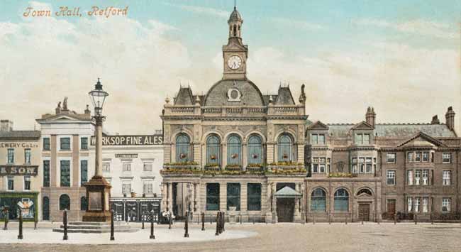
Retford Town Hall and the south side of the market square in 1905.
The small market town of Retford1 in north Nottinghamshire has historically been at the centre of a number of important communications networks but is now more frequently seen as a blur by long-distance travellers as they speed through on the east coast railway route.
Unlike Newark and Southwell no castle or major church is associated with Retford but it has been argued that its very ordinariness makes it "stand as a template for English small town life".2 It was the main town of the Bassetlaw Hundred and the place where the Quarter Sessions for North Nottinghamshire and the Commissioners for Musters met but local government reorganisation in 1974 led to the creation of Bassetlaw District Council and its headquarters was established in neighbouring Worksop, so Retford lost its pre-eminence.
Medieval Retford
Retford’s origins are obscure. Redford has several brief entries in Domesday Book (although the references are probably to West Retford) but it seems very likely that East Retford was established as a royal borough in about 1105 by Henry I "to compete with the trading privileges of Blyth priory and to exploit the market opportunities of north Nottinghamshire."3 As a royal borough Retford was second only to Nottingham in status. The parish and borough were coterminous and the area was very probably carved out of neighbouring parishes.
The year 1246 has traditionally been seen as a key date in the development of the town when Henry III granted to the burgesses of Retford and their descendents licence to hold one eight-day fair annually; they were also freed of various tolls and awarded the tolls of certain bridges, including one in the town itself. However, recent research has thrown doubt on the very existence of this charter.4 The charter of 1246 is only described in Piercy’s history of Retford published in 1828. However, it is certain that the earliest recorded charter was one of 1259 when Henry III granted an annual eight-day fair for the improvement of the borough, whereas the earliest extant charter dates from 1313 and marks the first mention of a market which was to be held each Saturday.
The charters also enshrined Retford’s rights to self-government without interference from the Sheriff of Nottinghamshire. Two bailiffs, aldermen and burgesses, elected from the town’s freemen, regulated the borough’s affairs.
The market place was the centre of the town’s commercial activity, although unusually the parish church was some distance away: it has been suggested that the open space between the church and the square (known as Cannon Square since the mid-19th century) may have been the original site of the market. The principal streets of Carr Hill Gate (Carolgate), Newgate (Grove Street), Churchgate or Kirkgate, and Bridgegate radiated out of the square. A moot hall (town hall) was built at the north end of the square in 1388 and a triangular plot of land to the north of the building was used as another market area.
There was a ford across the River Idle, linking East and West Retford, and the first reference to a bridge here dates from the 13th century. The town mills were next to the bridge and over time were used for fulling, grinding corn and paper-making. In addition to the built-up area there were about 50 acres of carrs and commons, communal pasture on the south side of the town.
The Lay Subsidy of 1334 assessed the borough at less than half the value of Newark although when the suburbs of Moorgate and West Retford are included the total increases to over £16, making it the third most prosperous town in Nottinghamshire, after Nottingham and Newark.5
16th-17th centuries
Retford was an important market town and administrative centre and "its horizons were always much wider than the shire of which it is a part".6 Fairs were held twice a year and were used to distribute cattle, horses, cheese and hops. By the close of the 17th century the town had come to treat the neighbouring settlements of West Retford, Thrumpton, Spital Hill, Moorgate and Bolham as suburbs.
The borough suffered three dreadful disasters during this period. A major fire in 1528 destroyed over three quarters of the borough and rebuilding only got underway in 1540. Another fire struck in 1585 (their neighbours in Worksop raised money for “the poor men of the late burned town of Retford”) and yet another fire caused £1,300 worth of damage in 1631. The conflagrations must have had a profound effect on both the economic development of the town and also the religious faith of its inhabitants. The same period saw several outbreaks of plague: an outbreak in 1558 was particularly severe with around 300 deaths in East Retford and West Retford suffered the loss of over half its population.
18th century
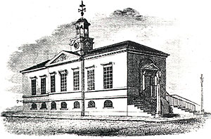
The old Town Hall in the 1820s.
By the mid-18th century Retford was described as "a borough, but no thorough fare, and chiefly subsists by hops, markets and fairs."7 However, improvements in the transport networks over the next 100 years would dramatically transform the town.
The Great North Road had passed a few miles to the west of the town for centuries until it was re-routed in 1766. Retford now lay on the main thorough route from London to the north and the road stimulated the local economy, the most sign of this being the number of inns that sprang up to service the passing trade. Subsequently, other routes out of Retford were turnpiked and improved: the Retford to Gainsborough road was turnpiked and a bridge built over the Trent at Gainsborough in 1787; the Retford to Worksop road was turnpiked in 1822.
The construction of the Chesterfield Canal also brought significant changes. James Brindley designed the canal and work started in October 1771; the canal was officially opened in June 1777. The canal ran for 46 miles contained 65 locks, 69 bridges, two tunnels and connected the River Trent with Retford, Worksop and Chesterfield. The Gentleman’s Magazine of 1777 observed that it was "already of prodigious advantage to the neighbouring country in conveying limes, coals, and other heavy articles, which are now carried at about one fifth part of the usual price of land-carriage and altogether as expeditious."8
Industrial development, however, was limited. Although there were small factories producing hats, paper, sail-cloth, sack-bags, hides and rope, attempts to create a textile industry in Retford foundered. In 1788 Major John Cartwright built The Revolution Mill on Spital Hill, near the Chesterfield Canal. The mill was a steam-powered wool spinning and weaving mill employing around 600 people. The ambitious enterprise, however, failed a few years later and the site and machinery was eventually sold at great loss in 1805. No trace of the complex has survived.
19th century
Retford’s political history is marked by the "cynical manipulations of the franchise" in the 1820s. The town only had 220 voters and their votes were fairly easy to bribe thus ensuring the return of candidates favoured by the Duke of Newcastle or other prominent landowners. However, by the 1790s the Newcastle interest was challenged by an independent group. The election of June 1826 was a troubled affair, the election result being declared invalid after an inquiry the following year after accusations of corruption. The issue was debated in parliament and the borough of East Retford was disenfranchised in 1830; at the same time its seats were transferred to the hundred of Bassetlaw and a new constituency of East Retford cum Bassetlaw created.
Throughout the rest of the 19th century Retford experienced a period of "slow, unspectacular development, not only as an entrepot for local trade, manufacture and business, a convergence of three important means of transport and a self-contained administrative unit, but also as a town in which people of at least moderate means could enjoy a comfortable and fruitful life."9
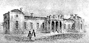
Thrumpton station in 1851.
The coming of the railways was the most significant event in Retford during this period: they transformed the town "from a small rural community into a thriving partly industrialised small town with an important railway junction."10 The Manchester, Sheffield and Lincolnshire railway arrived in 1849 and established a station in Thrumpton. Simultaneously, the Great Northern line between Retford and Doncaster was opened with a station in Ordsall Lane: the company completed the London to Edinburgh route in 1852. The hamlet of Thrumpton was rapidly developed as a new 'railway town' to accommodate the growing railway workforce.
Retford’s population doubled from 5,999 in 1801 to 12,340 by 1901 and the town’s expansion led to the extension of the borough’s boundaries. In 1878 the East Retford Borough Act ended the centuries of coterminosity of the borough and parish and allowed the town’s boundaries to encompass the parishes of West Retford and Ordsall and the hamlets of Bolham, Moorgate and Little Gringley.
Industrial activities diversified during the century. Paper production became increasingly important: the Bolham Paper Making Company’s mill made glazed papers, shop papers, boards, boxboards and new paper mills were built in the mid-19th century, including a mill on Albert Road in 1867. Foundries and iron works were also established. The Beehive Works was built in Thrumpton in 1873 and William Bradshaw set up his Carr Foundry in Albert Road which specialised in heating and rainwater pipes, gutters, stoves, fireplaces and general engineering castings. The late nineteenth century also saw the introduction of new technologies when the Northern Rubber Company was created by Alfred Pegler in 1871. The factory’s proximity to the junction of two important railways helped it prosper.
20th century
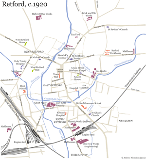 Map of Retford, c.1920 (click on the image to view a larger version of the map).
Retford’s population increased over the 20th century but not as dramatically as it did during the previous 100 years. In 1901 there were 12,340 inhabitants; by 2001 this had increased to 22,000.
Road congestion in Retford had become an issue as early as the 1920s when calls were made for the construction of a bypass. By the 1950s it was a chronic problem and relief only came when the A1 was opened to the west of the town in the 1960s. A bypass was constructed around the town centre in the 1970s.
The expansion of Retford’s housing stock was a key feature of the inter-war period. Building on the Hallcroft estate started in 1920 and sub-standard housing in Spital Hill was cleared in 1929 (216 houses had been erected by 1939). Major private developments (North Road estate, Welham Road to Tiln Lane area, Grove Coach Road to Bracken Lane area, Babworth Crescent etc) have been completed since World War II.
Traditional industries in Retford have, however, declined in recent years. Long-established companies such as Jenkins Newell Dunford (engineering) and Bridon Ropes (wire) both closed in 2004. Like so many other small towns, Retford is now dominated by large supermarkets and the service industries.
References
1. For the purposes of this research pathway, 'Retford'
comprises the borough of East Retford as well as the neighbouring settlements
of West Retford, Thrumpton, Moorgate, Bolham, Spital Hill and Little Gringley.
2. Bishop, M. W. ‘The Origins of East Retford’, Transactions
of the Thoroton Society, 82 (1978)
3. David Marcombe, English small town life. Retford 1520-1642,
Department of Adult Education, University of Nottingham (1993)
4. Dolby, M. ‘1246 and all that! A look at Retford’s historic
charters’, Retford & District Historical & Archaeological
Society Review, 4, 1997
5. Glasscock, R. E. The Lay Subsidy of 1334 (British Academy Records
of Social and Economic History n.s. II, 1975)
6. Marcombe, op cit.
7. Jackson, A. A history of Retford. The growth of a Nottinghamshire
borough. Retford, Eaton Hall College of Education, 1971
8. Jackson, op cit.
9. Jackson, op cit.
10. Jackson, op cit.
![]()
![]()