
Cartographic
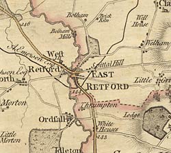 Detail of Chapman's map of Nottinghamshire
(1774) showing the Retford area.
Detail of Chapman's map of Nottinghamshire
(1774) showing the Retford area.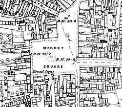
Detail of the 1886 Ordnance Survey 25" to the mile map of Retford showing the market square.
Printed
John Chapman’s map of Nottinghamshire (1774) is the earliest printed map at a sufficiently useful scale (1 statute mile to one inch) to provide basic information on town and village layout and the existence of landscape features such as roads, parkland and mills. A facsimile version was published by Nottinghamshire County Council in 2003.
George Sanderson’s map of the county twenty miles around Mansfield, originally published in 1835, covers most of Nottinghamshire at a useful scale of 2¼ inches to 1 mile (showing fields, individual buildings, roads, industrial sites, parish and township boundaries, etc) has been produced by Nottinghamshire and Derbyshire Library Services:
- George Sanderson, Twenty miles around Mansfield, 1835 (Reprinted by Derbyshire and Nottinghamshire County Councils, 2001)
Ordnance Survey
Large scale Ordnance Survey maps from the late 19th and early 20th centuries show the town and its features in great detail:
- 1:2500 (25” to the mile) and 1:10560 (6” to the mile) published in 1884 (1st revision in 1898; 2nd revision in 1916)
- 1:500 (10 feet to the mile) published in 1884 in 17 sheets
These maps are available online:
Manuscript
National Archives
- Plan of the Parish of East Retford In the County of Nottingham, 1850 (Tithe map) [IR 30/26/101]
Nottinghamshire Archives
- Map of the Manor of West Retford by W. Kelk, 1774 [WR 1 L]
- A map of the hamlet of Moorgate in the parish of Clarbrough … by Jas. Dowland, early 19th century [Map Cabinet (EA)]