
|
|
|
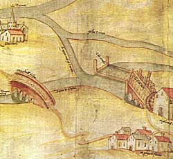 |
| Detail from a map of the Trent, c.1500. The extract shows the "mylne of Newarke" with its floodgates and causeway, "Olde Trente" and "Markall Bridge" (Markham Bridge). |
The nature and location of resources
Cartographic
Printed
The Trent and other major rivers in the country are shown diagrammatically in plate... of Michael Draytons Polyolbion (1621), a long poetic account of Britain using rivers for the core narrative structure (copies of maps in Nottinghamshire Local Studies Library).
County maps, 1576-1820s are listed by F A Wadsworth in TTS 34 (1930). Copies are held in Nottinghamshire Local Studies Library and Nottinghamshire Archives.
From the 1830s Ordnance Survey maps have been produced for the whole county at a scale of 1in to 1 mile or larger. Copies in Nottinghamshire Local Studies Library, Nottinghamshire Archives and British Library. There are facsimile reprints of the Old Series published by David & Charles and the Third Edition published by Alan Godfrey still in print.
Manuscript
There are variety of manuscript maps of part of the county showing portions of rivers. These date from the 14thC to the 19thC and are listed in Harold Nichols, Local maps of Nottinghamshire to 1800 (1987). Published examples include:
- Rivers in Sherwood Forest in 1609 in S Mastoris & S Groves, TSRS 40.
- Portions of the Trent at Shelford and near Newark in the 1590s, in S Revill, TTS, vol.75, and C Salisbury, TTS, vol.87.
- Some general information in Probate inventories/title deeds of fisheries
© THOROTON SOCIETY | CREATED: 8 March 2003 | UPDATED: 6 July 2003