
|
|
|
The nature and location of resources
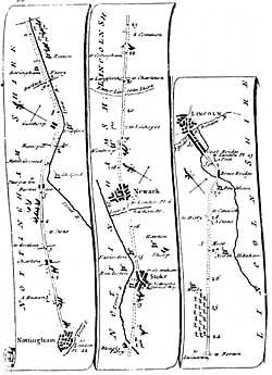 |
| Excerpt showing the route between Nottingham and Lincoln from Kitchen's Post-haise Companion published in 1767. |
Cartographic
Printed
Although no roads are shown on Saxtons map of Nottinghamshire (1576), a number of crossing points of rivers and boundaries are indicated on this map, providing some indication of the location of major roads in the county at this time.
The first detailed mapping of the main roads in the county was undertaken by Ogilvy in his Britannia (1679). However these are depicted in strip form and do not provide an overall representation of the location of roads in the county landscape. See plates 6, 7, 48, 78
Detailed depiction of the countys road system are found in the maps of by Chapman (1774); Sanderson (1834) and the Ordnance Survey (1840s onwards).
Manuscript
The earliest depiction of the road system in the county is shown on the early 14th-century Gough Map of England (Bodleian Library – reproduction available. More detailed information is available in a crude map of Sherwood Forest, created c.1600 (TTS, 102). During the first half of the 17th century there are a considerable number of large scale estate maps that also showing road systems (listed in Nichols). In the 18th century parish enclosure maps frequently provide detailed information about roads and trackways.
© THOROTON SOCIETY | CREATED: 7 March 2003 | UPDATED: 6 July 2003