
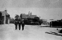
 The Village Square, c.1900.
The village of West Bridgford grew up by the south bank of the River Trent, where the land was level. Further south it rises slightly. The original boundaries of the parish were south of the river (probably following an old course of the river) to the north, and on the west along Loughborough Road as far as about Eton Road and then it was to the east of Loughborough Road. On the east side it bordered Gamston. It is bounded by Wilford to the west, Edwalton to the south and Holme Pierrepont to the east. In 1935 Wilford and Edwalton were added to West Bridgford Urban District and in 1951 the boundary changed when Wilford became part of the city and the northern boundary was deemed to run along the middle of the river.
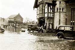 The Village Square became known as Tudor Square with the advent of the Tudor Cinema. The photograph is from 1947, the last major flood in West Bridgford.
There had been a bridge over the river to Nottingham since 924. Over the centuries it has been rebuilt after flood damage. The present Trent Bridge was first built in 1871, designed by M. O. Tarbotton. It was widened in 1926 to take four lanes of traffic. Three roads, originally turnpiked, joined in West Bridgford to cross the river at Trent Bridge. The Loughborough Road and Melton Road joined Wilford Lane (not turnpiked) south of the bridge. The Radcliffe (originally named Grantham) Road joins the others nearer to the bridge. For a time this was the only crossing point but two railway bridges were built later. The one at Lady Bay was altered after the railway line closed and now takes road traffic. The other railway bridge near Wilford has been demolished. Although two railway lines went through Bridgford there was never a station in the village. A pedestrian suspension bridge, built to carry water pipes, is still in use and is reached from Welbeck Road. The Grantham Canal opened in 1797, built primarily to take coal to Grantham, passes through West Bridgford before joining the River Trent. It was closed in 1936.
In 1086 West Bridgford was part of the lands of William Peverel. At the beginning of the 13th century the manor of Gamston and West Bridgford was held by Geoffrey Lutterel. A further seven generations of Lutterels held the manor until 1419 when the last Geoffrey died without a male heir and the manor passed to his sister Hawise and her husband Godfrey Hilton. After two generations the manor again passed through marriage to Richard Thimelby. His great grandson sold the manor in 1592 to Sir Henry Pierrepont. The following year, 1593, the parish registers note that “the Plague was in Nottingham and in some places in West Bridgford”.
At the start of the Civil War, West Bridgford had a Royalist Rector, but he was soon taken into custody by the Hosue of Commons and his living was sequestered. In 1645, The Newark horse plundered the village and carried away every man they could find as prisoners. Six men tried to take refuge in the church but the Royalists broke open the doors and took them away. In 1650 Samuel Coates, who had served as an officer in Cromwell’s army. was appointed Rector. In 1692, and again in 1710, the Lady of the Manor, Mrs Fuller, enclosed areas of common grazing ground.
In due course, the manor passed to John Musters and continued in this family. A later John married Mary Ann Chaworth and the family surname was changed to Chaworth-Musters. In 1880 their grandson, also John, decided to sell some of the land for building. Very strict conditions were made as to size of properties and what could not be built in the village. The first land was offered for leasehold but later plots were freehold. It included land on the east side which formed the area known as Lady Bay. From this time building has continued and no farms remain now. The population, which remained at between 200 and 300 during the 18th and early 19th centuries, rose dramatically with the new housing, reaching 2,502 by 1891. In 2011 the population of West Bridgford and Edwalton was 45,509.
The oldest building in West Bridgford is St Giles’ church, which dates from the end of the 12th century. As the village grew in the late 19th century the church was extended, first by a main aisle added in 1898 and then by a north aisle in 1912.The Victorian rectory was demolished in 1960 and replaced on part of the same site on Rectory Road. This in turn was demolished and a newer rectory built on Bridgford Road. As the village grew other denominations built churches on Musters Road – the Methodists in 1888, the Friary Congregational (now U R C) in 1901 and the Baptists in 1907. A Catholic church was built on Victoria Road in 1930 and was replaced by a new building in 1976. There was also a church at Lady Bay and a Methodist church there. Schools were also needed and the first village school built in 1840 was succeeded in 1866 by a National school and then a Board school. As the village grew so new schools, both primary and secondary, were erected.
The Hall, started by Mundy Musters in 1768 and completed by his son John in 1774, is the other main building. It was not used by the Musters family who resided in their other property Colwick Hall, but was let to tenants. In 1883 the hall was sold to Albert Heymann, a Nottingham banker. In 1923 it was sold to West Bridgford Urban District Council for their offices. Following extensive refurbishment, the Hall opened as an apart-hotel in 2017.
The Peatfield Almshouses were built on Rectory Road in 1892 and still provide homes for elderly residents. Miss Peatfield, the last of the family, had lived at the Poplars, a large house on Rectory Road. This was demolished after her death and a block of apartments built on the site.
West Bridgford was always an agricultural village until the early 20th century. In 1811 a rental shows 21 farms of which the largest was 122 acres. The smaller farms were pasture for animals with just small amounts of crops, mainly for animal feed. The larger farms had almost equal pasture and arable land. There were less farms in a rental of 1861 when the two largest were 155 and 144 acres. In 1870 of the 1,140 acres 738 acres were pasture, 269 acres cereal crops and 133 acres were green crops such as peas and beans. By 1900 only 693 acres was farmed of which 429 acres was pasture. By the 1920s many of the farms and their buildings had gone.
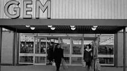
GEM supermarket
In the 1880s a brick works was opened at Ludlow Hill on Melton Road. This provided for the growing building in the village. Modern West Bridgford has only light and service industries and provides accommodation for workers commuting to Nottingham and further afield. The centre of the town is still small and in the 21st century is dominated by cafés and restaurants. There are small groups of shops near the housing areas but there is no large retail park. However Bridgford did have the first supermarket, GEM, built in 1964 on the site of the last farm, Collington’s, which was demolished in 1964. In 1966 GEM was bought by ASDA and still trades as that at the present time.
Leisure activities have been well supplied since the growth of Bridgford. The Nottinghamshire County Cricket Club and Nottingham Forest Football Club both have grounds near to Trent Bridge. There are also sailing clubs by the river. There are several amateur sports clubs for both adults and children available. Cultural provision has also been made and over the years groups covering many different activities have flourished.
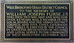
Tablet to William J Furse, who played a key role in the transformation of West Bridgford from village to town.
In 1894 West Bridgford had one of the first Urban District Councils. This remained in force until 1974 when Rushcliffe Borough Council was set up. In 1914 the UDC began its own bus service, which later ran in conjunction with Nottingham Corporation buses. This continued until 1968. Nottingham has made several attempts to take West Bridgofrd within its own boundary but so far has been successful in fending them off.
![]()
![]()